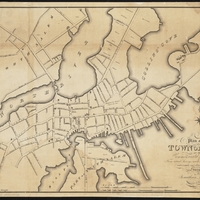
Plan of the Town of Salem
Item
- Title
- Description
- Contributor
- Coverage
- Creator
- Date
- Format
- Language
- Rights
- Source
- Type
- Tag
-
Plan of the Town of Salem
-
Scanned from Mr. Samuel McIntire, carver, the architect of Salem, fig. 16. Created from surveys made in 1796 & 1805. From Salem State University Archives: “This map, prepared in 1820 but based on surveys from 1796 and 1804, offers a point of comparison for studying both “change over time,” and also a different perspective from the contemporary Bowditch Chart, above, Note the detail of wharves on Derby St. and Stage Point.”Physical copy of map located at Salem Public Library, Maps vertical file. Digital copy available at the Norman B. Leventhal Map Center.
-
Institution: Salem Public Library
-
Institution: Boston Public Library
-
Massachusetts--Essex (county)--Salem
-
Saunders, Jonathan Peele, 1785-1844
-
1820
-
image/jpg
-
eng
-
No copyright restrictions.
-
Mr. Samuel McIntire, carver, the architect of Salem by Fiske Kimball. (*B/ MCINTIRE, S./K/SAL. COLL.)
-
cartographic
-
map
-
Salem
- Item sets
- Salem Maps
- Media
 1820_Saunders(small).JPG
Position: 8663 (1 views)
