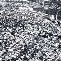
Aerial view of Wakefield, circa 1936
Item
- Title
- Aerial view of Wakefield, circa 1936
- Description
- "This aerial view of Wakefield, taken sometime around 1936, provides a look at Main Street in the downtown area. Main Street runs horizontally through the center of the photo, and shows several buildings that are no longer standing, including Wakefield High School (later called the Atwell Building) at the bottom right, the old Wakefield Town Hall near the center of the photo, the Miller Piano Factory behind the Town Hall, the Wakefield Building with its top floor, the buildings which housed the Wakefield Rattan Company (later the Robie Industrial Park) on Water Street near the top right of the photo, the stores and homes that stood on Main Street before they were razed during the 1940s, and the Methodist Episcopal Church on Albion Street that was torn down in 1938. The photo also shows the L.B. Evans' Son Co. Shoe factory on Water Street, the railroad that at one time traveled to Peabody and Newburyport, and the lot of land that would eventually house the Post Office next to the Lucius Beebe Memorial Library."
- Image from the Wakefield Municipal Gas and Light Department annual calendar, 2016
- Photo from the collection of the late Murray Young, courtesy of David Parr
- Contributor
- Institution: Lucius Beebe Memorial Library
- Wakefield Municipal Gas & Light Department (Wakefield, Mass.)
- D'Onofrio, Jayne M.
- Coverage
- Massachusetts--Middlesex (county)--Wakefield
- Date
- ca. 1936
- Format
- image/jpeg
- Publisher
- Wakefield, Mass. : Wakefield Municipal Gas & Light Department
- Subject
- Aerial views
- Type
- still image
- Photographs
- Original Format
- 1 picture: b & w
- Extent
- 30 x 18 cm.
- Media
 mld16_february.jpg
